NB Naturalist Feature: Beach Debris Surprises With A Valuable Find
By: Donald MacPhail, with Dr Marc Trudel

For the last couple of years, my wife and I and a few friends have tried to keep a couple of beaches on Deer Island in the Bay of Fundy clear of human-made debris.
When we started, there were large rope balls, tangled up nets and big plastic pipes. When alerted, the local aquaculture companies responded with a boat crane and lifted the big stuff off the beach. But there were also binloads of stuff that we picked up by hand.
A new supply arrives with every high tide. Two by fours may be sort of benign environmentally, but there are always lots of plastic drink bottles (only a few with messages inside!), plenty of crumbly Styrofoam, loads of lobster claw elastics – and rope. All kinds and colours and lengths of rope
Surprisingly, perhaps (or perhaps not?) it’s not all from far off corners of the world. A few lobster tags were from Maine, but items with a label on them are usually in French and English so we can deduce where they originated. Almost all the garbage that comes in on every tide is from local sources.
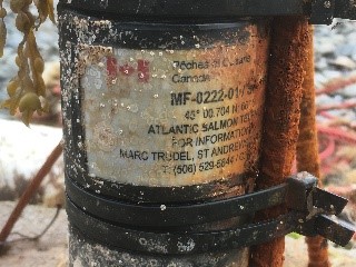
But one day in September 2020, there was a large item on the beach that had a return address on it. A name, contact info and even a plea to please call if found.
At 9:59 the next morning I emailed a photo of the item to Marc Trudel. At 10:04 I had an email back saying basically, “We’ve been looking for that!”
According to Dr Marc Trudel, what we had found on the beach was an underwater device that picked up “pings” from fish that had been fitted with acoustic transmitters. Marc is a research scientist with Fisheries and Oceans Canada, based at the St Andrews Biological Station, and he explained the program to us.

The science part of the device is a black metal cylinder about the size and shape of a water bottle. It holds a battery, a microphone, and a recording device, each of them able to operate underwater for about a year and a half. The cylinder is attached to a steel frame made of rebar and has a concrete base to hold the device on the seafloor. A length of rope attaches the gear to a flotation device so it can be recovered.
The particular fish that Marc was listening for were Tobique River salmon stock that had been raised in substrate ponds at the Mactaquac Biodiversity Facility near Fredericton and released into the Magaguadavic River both above and below the falls at St George where the river enters the Bay of Fundy. Ideally, Magaguadavic River salmon stock would be used, but there are so few salmon now in that river that genetically similar salmon must be used in order to do this type of work.
It is one of 129 similar devices placed around Passamaquoddy Bay in 2019. The devices were arranged to achieve two main objectives. One was to learn how much time the fish spend in the bay and which channels between the various islands at the mouth of Passamaquoddy Bay they use to reach the Bay of Fundy and the Atlantic Ocean beyond.
The second reason was to determine whether river-released salmon spend a lot of time around aquaculture cages. Interestingly, the tagged salmon do not seem to linger around the salmon cages. The average time they spend in the area is only about sixteen minutes according to data from these devices. The device we found had been placed close to an aquaculture site and had perhaps been moved by currents during the summer of 2019 as it could not be found in August of that year. It turned up a year later about 100 metres from where it had been deployed.
A biologist from DFO, Brent Wilson, picked up the unit within a few hours of our initial exchange and by mid-afternoon that day I got a report from Marc as to what it had “heard”. Twelve of the 160 tagged salmon had passed by the device as had several fish that had been tagged by other researchers.
Marc told us all data would be submitted to an organization called the Ocean Tracking Network which checks it for errors and false detections, and then sends a report to the appropriate research organizations on “their fish”. Based on having seen similar tag codes before, he suspected that some of the other fish were sturgeon. This was confirmed later by contacting the researchers associated with those tag codes. Three sturgeon had been detected – two had been tagged in the Minas Basin and one had been tagged in New England. (Another device had picked up a sturgeon that had been tagged in the St. Lawrence River near Quebec City.)
And there were “pings” from Great White Sharks. As Marc said, “We had 35 “pings” in total from three different sharks. Two females, each measuring almost three metres long, that had been tagged off New England (one named Newton and the other named Ocean-Maia by the team that tagged them) and one female, measuring about four metres long, that had been tagged off Nova Scotia.”
Another bit of data that the transmitter on the fish sends out is temperature. This helps give an indication of water temperatures the fish prefer. It also indicates, when the temperature suddenly and significantly increases, that a fish has been eaten… most likely by a warm-blooded seal that has passed by the detector with the fish in its belly!
The device we found was not the only one that had been lost. One is known to be entangled in a channel marker. Marc hopes to recover it when the marker is next pulled out of the water for servicing. Three others, so far, have also been lost. Marc feels that two are floating around in the bay somewhere and one is likely in Cobscook Bay, Maine.
For the complete story on the tagging and detection program, and the findings so far, you can watch the online presentation Marc has made in both French and English.
I’m not sure that we will find any beach junk that is more interesting than what we found that day and we may not find much with a return address either, but we will continue to try and keep these few beaches clear of plastic and other human-generated debris. And hope that, with time, there will be less to clean up.

Location of the acoustic receivers deployed in the Passamaquoddy Bay area and Magaguadavic River in 2019 (white circles). The red star represents the original deployment location of the receiver that was retrieved on the beach on Deer island.


